
【研究意义】
随着水电工程的大规模建设与运行,以及极端气候事件日益频繁,库岸斜坡的稳定性面临严峻挑战,大量斜坡出现缓慢移动甚至局部崩塌现象,导致库区滑坡风险显著上升。然而,对于这类滑坡的运动学特征及其驱动因素,当前认知仍极为有限。尽管缓慢移动的水库滑坡直接造成大量人员伤亡的情况较为罕见,但一旦其活动模式突然转变为快速滑动,将对重大基础设施和社区安全构成严重威胁,对人居环境及区域可持续发展产生极为不利的影响。缓慢移动的滑坡体实际上为科学研究提供了一个天然的实验室,通过长期的原位观测,能够深入揭示其演化特征与触发机理,为滑坡的预测预警及风险管理奠定坚实的数据基础。
在库区滑坡地质灾害管理领域,实施多因子协同预警对于提升响应效率和减灾能力具有至关重要的意义。尽管基于地表位移的滑坡预测预警技术已得到广泛研究和应用,但由于缺乏地下实时观测数据,我们对触发滑坡加速变形的临界条件的准确预测能力仍然受到严重限制。
【研究内容】
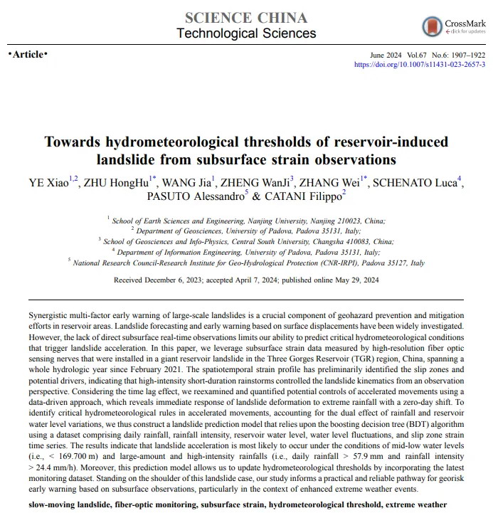
南京大学朱鸿鹄教授课题组与意大利国家研究委员会地质水文保护研究所(National Research Council-Research Institute for Geo-HydrologicalProtection, CNR-IRPI)、帕多瓦大学(University of Padova)滑坡研究团队携手,对藕塘滑坡这一具有数十年监测历史的特大型缓慢移动滑坡案例展开了深入研究。借助高时空分辨率的光纤神经系统(Fiber Optic Nerve System, FONS),团队获取了自2021年2月起涵盖一个完整水文年的地下应变数据。前期研究揭示,短时强降雨是引发滑坡加速运动的关键因素。在此基础上,考虑到滑坡变形的时滞效应,本研究利用数据驱动方法,重新审视并量化了滑坡加速运动的潜在控制因素,明确了滑坡变形对极端降雨的即时响应特性。
为明确滑坡加速变形的临界水文气象条件,本研究基于地下应变数据和增强决策树算法,开发了一个滑坡预测模型。该模型综合考虑了降雨和库水位的影响,融合了日降雨量、降雨强度、库水位高程、水位波动以及滑带应变时间序列数据,并根据滑带应变特征,将其聚类为近稳态、加速变形和稳态三种。研究结果显示,滑坡加速变形最有可能在中低水位(即水位高程低于169.7 m)且伴有大量降雨或高强度降雨(即日降雨量超过57.9 mm或降雨强度超过24.4 mm/h)的情况下发生。这种多因子协同的滑坡预警策略极大地缩短了地质灾害风险管理的时间窗口,为相关决策部门提供了快速风险评估和应急响应的能力。
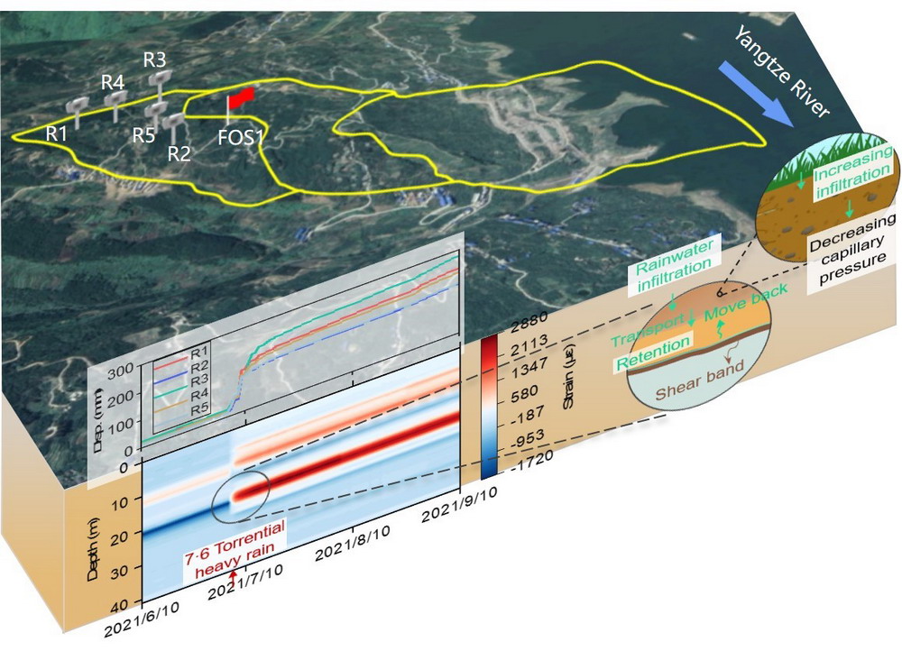
图1 GNSS地表位移时间序列与FOS地下应变时空剖面
研究人员通过多次野外调研,验证了所提出的水文气象预警准则的有效性。在 2021 年极端降水条件下,短时高强降雨触发了显著的滑坡运动;而在 2022 年极端干旱条件下,滑坡的整体变形则明显减小。本研究旨在为特大型库区滑坡灾害管理提供一个实用的早期预警和应急管理框架,以应对近年来极端水文气象事件频发的新局面。未来研究将通过引入滑带土温度和含水率等原位数据,进一步优化预测模型,提升滑坡早期预警的准确性和有效性,并在此基础上深入探究地下热 – 水 – 力相互作用的本质。
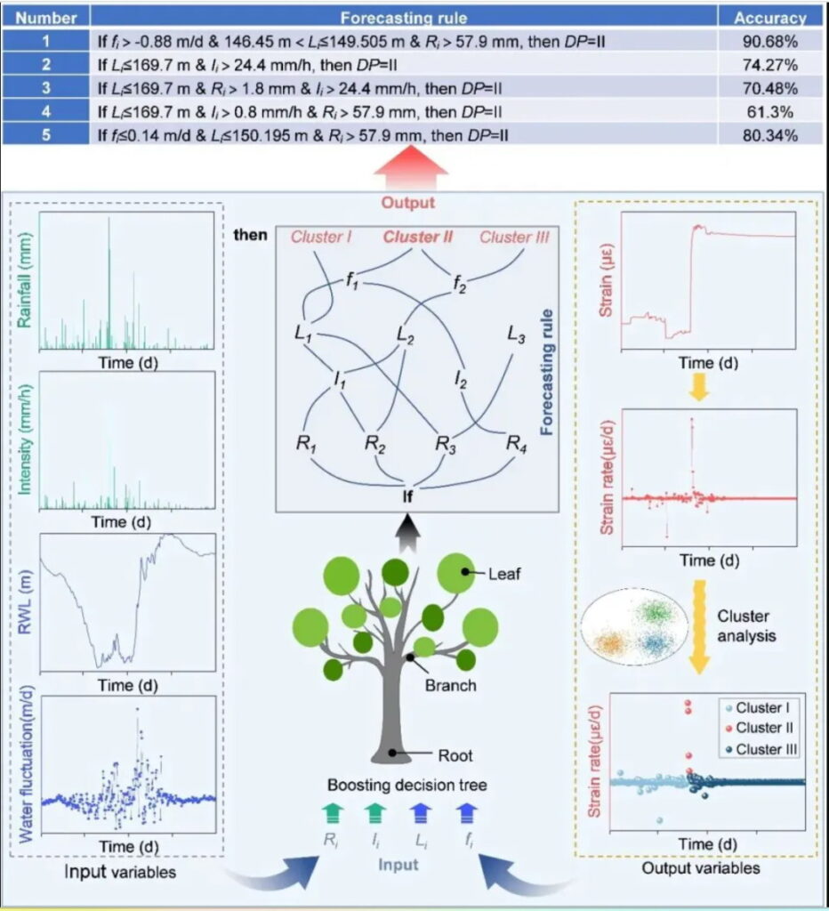
图2 基于滑带应变的增强决策树模型与多因子协同预警策略
图3 极端降水/干旱水文年可能触发滑坡加速运动的降雨事件特征
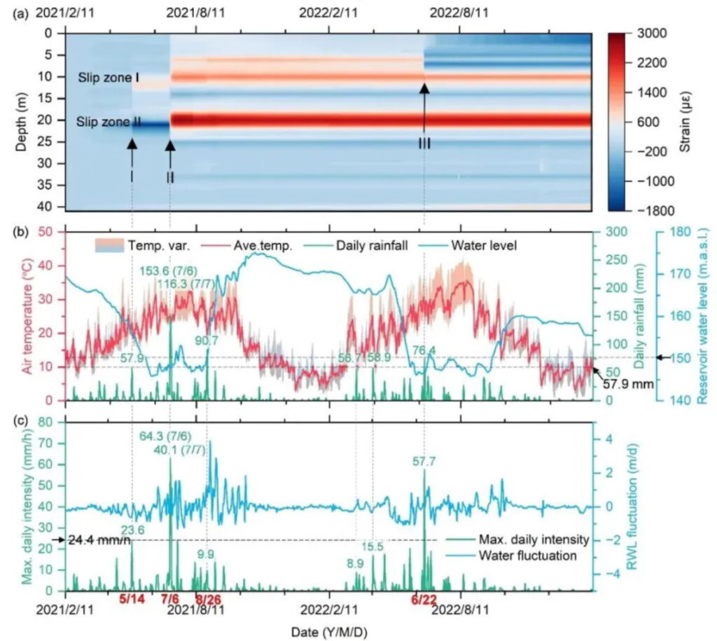
图4 现场监测结果及其同期水文气象记录
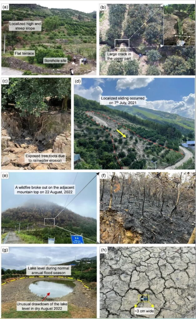 图5 揭示滑坡运动学特征和验证早期预警准则的现场证据
作者:叶霄,朱鸿鹄,王佳,郑万基,张巍,SCHENATO Luca, PASUTO Alessandro,CATANI Filippo
引用格式:Ye X, Zhu H H, Wang J, et al. Towards hydrometeorological thresholds of reservoir-induced landslide from subsurface strain observations. Sci China Tech Sci, 2024, 67: 1907–1922, https://doi.org/10.1007/s11431-023-2657-3
Towards hydrometeorological thresholds of reservoir-induced landslide from subsurface strain observations
YE Xiao 1,2, ZHU HongHu 1*, WANG Jia 1, ZHENG WanJi 3, ZHANG Wei 1*, SCHENATO Luca 4, PASUTO Alessandro 5, CATANI Filippo 2
1 School of Earth Sciences and Engineering, Nanjing University, Nanjing 210023, China;
2 Department of Geosciences, University of Padova, Padova 35131, Italy;
3 School of Geosciences and Info-Physics, Central South University, Changsha 410083, China;
4 Department of Information Engineering, University of Padova, Padova 35131, Italy;
5 National Research Council-Research Institute for Geo-Hydrological Protection (CNR-IRPI), Padova 35127, Italy
*Corresponding authors (emails: zhh@nju.edu.cn; wzhang@nju.edu.cn)
Abstract: Synergistic multi-factor early warning of large-scale landslides is a crucial component of geohazard prevention and mitigation efforts in reservoir areas. Landslide forecasting and early warning based on surface displacements have been widely investigated. However, the lack of direct subsurface real-time observations limits our ability to predict critical hydrometeorological conditions that trigger landslide acceleration. In this paper, we leverage subsurface strain data measured by high-resolution fiber optic sensing nerves that were installed in a giant reservoir landslide in the Three Gorges Reservoir (TGR) region, China, spanning a whole hydrologic year since February 2021. The spatiotemporal strain profile has preliminarily identified the slip zones and potential drivers, indicating that high-intensity short-duration rainstorms controlled the landslide kinematics from an observation perspective. Considering the time lag effect, we reexamined and quantified potential controls of accelerated movements using a data-driven approach, which reveals immediate response of landslide deformation to extreme rainfall with a zero-day shift. To identify critical hydrometeorological rules in accelerated movements, accounting for the dual effect of rainfall and reservoir water level variations, we thus construct a landslide prediction model that relies upon the boosting decision tree (BDT) algorithm using a dataset comprising daily rainfall, rainfall intensity, reservoir water level, water level fluctuations, and slip zone strain time series. The results indicate that landslide acceleration is most likely to occur under the co、nditions of mid-low water levels (i.e., < 169.700 m) and large-amount and high-intensity rainfalls (i.e., daily rainfall > 57.9 mm and rainfall intensity > 24.4 mm/h). Moreover, this prediction model allows us to update hydrometeorological thresholds by incorporating the latest monitoring dataset. Standing on the shoulder of this landslide case, our study informs a practical and reliable pathway for georisk early warning based on subsurface observations, particularly in the context of enhanced extreme weather events.
Keywords: slow-moving landslide, fiber-optic monitoring, subsurface strain, hydrometeorological threshold, extreme weather
1 Min S K, Zhang X B, Zwiers F W, et al. Human contribution to moreintense precipitation extremes. Nature, 2011, 470: 378–381
2 Froude M J, Petley D N. Global fatal landslide occurrence from 2004 to 2016. Nat Hazards Earth Syst Sci, 2018, 18: 2161–2181
3 Cendrero A, Forte L M, Remondo J, et al. Anthropocene geomorphic change. Climate or human activities? Earths Future, 2020, 8: e2019EF001305
4 Dille A, Dewitte O, Handwerger A L, et al. Acceleration of a large deep-seated tropical landslide due to urbanization feedbacks. Nat Geosci, 2022, 15: 1048–1055
5 Ozturk U, Bozzolan E, Holcombe E A, et al. How climate change and unplanned urban sprawl bring more landslides. Nature, 2022, 608: 262–265
6 Haque U, da Silva P F, Devoli G, et al. The human cost of global warming: Deadly landslides and their triggers (1995–2014). Sci Total Environ, 2019, 682: 673–684
7 Ye X, Zhu H H, Wang J, et al. Subsurface multi-physical monitoring of a reservoir landslide with the fiber-optic nerve system. Geophys Res Lett, 2022, 49: e2022GL098211
8 Schuster R L. Reservoir-induced landslides. Bull Int Assoc Eng Geol, 1979, 20: 8–15
9 Deng J H, Wei J B, Min H, et al. Response of an old landslide to reservoir filling: A case history. Sci China Ser E-Tech Sci, 2005, 48: 27–32
10 Paronuzzi P, Rigo E, Bolla A. Influence of filling-drawdown cycles of the Vajont reservoir on Mt. Toc slope stability. Geomorphology, 2013, 191: 75–93
11 Tang H M, Wasowski J, Juang C H. Geohazards in the Three Gorges Reservoir Area, China—Lessons learned from decades of research. Eng Geol, 2019, 261: 105267
12 Yin Y P, Huang B L, Wang W P, et al. Reservoir-induced landslides and risk control in Three Gorges Project on Yangtze River, China. J Rock Mech Geotech Eng, 2016, 8: 577–595
13 Zhou C, Cao Y, Yin K L, et al. Characteristic comparison of seepage driven and buoyancy-driven landslides in Three Gorges Reservoir area, China. Eng Geol, 2022, 301: 106590
14 Handwerger A L, Roering J J, Schmidt D A. Controls on the seasonal deformation of slow-moving landslides. Earth Planet Sci Lett, 2013, 377-378: 239–247
15 Hungr O, Leroueil S, Picarelli L. The Varnes classification of landslide types, an update. Landslides, 2014, 11: 167–194
16 Alonso E E. Triggering and motion of landslides. Géotechnique, 2021, 71: 3–59
17 Lacroix P, Handwerger A L, Bièvre G. Life and death of slow-moving landslides. Nat Rev Earth Environ, 2020, 1: 404–419
18 Yin Y P, Liu X J, Zhao C Y, et al. Multi-dimensional and long-term time series monitoring and early warning of landslide hazard with improved cross-platform SAR offset tracking method. Sci China Tech Sci, 2022, 65: 1891–1912
19 Veveakis E, Vardoulakis I, di Toro G. Thermoporomechanics of creeping landslides: The 1963 Vaiont slide, northern Italy. J Geophys Res, 2007, 112: F03026
20 AghaKouchak A, Huning L S, Chiang F, et al. How do natural hazards cascade to cause disasters? Nature, 2018, 561: 458–460
21 Xu Q, Yuan Y, Zeng Y P, et al. Some new pre-warning criteria for creep slope failure. Sci China Tech Sci, 2011, 54: 210–220
22 Segoni S, Piciullo L, Gariano S L. A review of the recent literature on rainfall thresholds for landslide occurrence. Landslides, 2018, 15: 1483–1501
23 Guzzetti F. Invited perspectives: Landslide populations—Can they be predicted? Nat Hazards Earth Syst Sci, 2021, 21: 1467–1471
24 Hidayat R, Sutanto S J, Hidayah A, et al. Development of a landslide early warning system in Indonesia. Geosciences, 2019, 9: 451
25 Guzzetti F, Gariano S L, Peruccacci S, et al. Geographical landslide early warning systems. Earth-Sci Rev, 2020, 200: 102973
26 Guzzetti F, Peruccacci S, Rossi M, et al. The rainfall intensity-duration control of shallow landslides and debris flows: An update. Landslides, 2008, 5: 3–17
27 Segoni S, Rosi A, Rossi G, et al. Analysing the relationship between rainfalls and landslides to define a mosaic of triggering thresholds for regional-scale warning systems. Nat Hazards Earth Syst Sci, 2014, 14: 2637–2648
28 Althuwaynee O F, Pradhan B, Ahmad N. Estimation of rainfall threshold and its use in landslide hazard mapping of Kuala Lumpur metropolitan and surrounding areas. Landslides, 2015, 12: 861–875
29 Wang N, Cheng W M, Lombardo L, et al. Statistical spatiotemporal analysis of hydro-morphological processes in China during 1950–2015. Stoch Environ Res Risk Assess, 2021, 36: 2377–2397
30 Caine N. The rainfall intensity-duration control of shallow landslides and debris flows. Geografiska Annaler-Ser A Phys Geography, 1980, 62: 23–27
31 Keefer D K, Wilson R C, Mark R K, et al. Real-time landslide warning during heavy rainfall. Science, 1987, 238: 921–925
32 Baum R L, Godt J W. Early warning of rainfall-induced shallow landslides and debris flows in the USA. Landslides, 2010, 7: 259–272
33 Huang F M, Chen J W, Liu W P, et al. Regional rainfall-induced landslide hazard warning based on landslide susceptibility mapping and a critical rainfall threshold. Geomorphology, 2022, 408: 108236
34 Mathew J, Babu D G, Kundu S, et al. Integrating intensity-duration based rainfall threshold and antecedent rainfall-based probability estimate towards generating early warning for rainfall-induced landslides in parts of the Garhwal Himalaya, India. Landslides, 2014, 11: 575–588
35 Sarhadi A, Soulis E D. Time-varying extreme rainfall intensity-duration-frequency curves in a changing climate. Geophys Res Lett, 2017, 44: 2454–2463
36 Zhang X B, Zwiers F, Li G L, et al. Complexity in estimating past and future extreme short-duration rainfall. Nat Geosci, 2017, 10: 255–259
37 Mirus B B, Becker R E, Baum R L, et al. Integrating real-time subsurface hydrologic monitoring with empirical rainfall thresholds to improve landslide early warning. Landslides, 2018, 15: 1909–1919
38 Espeholt L, Agrawal S, Sønderby C, et al. Deep learning for twelve hour precipitation forecasts. Nat Commun, 2022, 13: 5145
39 Ma J W, Tang H M, Liu X, et al. Establishment of a deformation forecasting model for a step-like landslide based on decision tree C5.0 and two-step cluster algorithms: A case study in the Three Gorges Reservoir area, China. Landslides, 2017, 14: 1275–1281
40 Casagli N, Intrieri E, Tofani V, et al. Landslide detection, monitoring and prediction with remote-sensing techniques. Nat Rev Earth Environ, 2023, 4: 51–64
41 Nava L, Carraro E, Reyes-Carmona C, et al. Landslide displacement forecasting using deep learning and monitoring data across selected sites. Landslides, 2023, 20: 2111–2129
42 Zeng T R, Glade T, Xie Y Y, et al. Deep learning powered long-term warning systems for reservoir landslides. Int J Disaster Risk Reduction, 2023, 94: 103820
43 Ye X, Zhu H H, Chang F N, et al. Revisiting spatiotemporal evolution process and mechanism of a giant reservoir landslide during weather extremes. Eng Geol, 2024, 332: 107480
44 Sang H W, Zhang D, Gao Y L, et al. Strain distribution based geometric models for characterizing the deformation of a sliding zone. Eng Geol, 2019, 263: 105300
45 Acharya A, Kogure T. Application of novel distributed fibre-optic ensing for slope deformation monitoring: A comprehensive review. Int J Environ Sci Technol, 2022, 20: 8217–8240
46 Bogaard T, Greco R. Invited perspectives: Hydrological perspectives on precipitation intensity-duration thresholds for landslide initiation: Proposing hydro-meteorological thresholds. Nat Hazards Earth Syst Sci, 2018, 18: 31–39
47 Miao H B, Wang G H. Prediction of landslide velocity and displacement from groundwater level changes considering the shear rate-dependent friction of sliding zone soil. Eng Geol, 2023, 327: 107361
48 Dai Z W, Yin Y P, Wei Y J, et al. Deformation and failure mechanism of Outang Landslide in Three Gorges Reservoir area. J Eng Geol, 2016, 24: 44–55
49 Luo S L, Huang D. Deformation characteristics and reactivation mechanisms
of the Outang ancient landslide in the Three Gorges Reservoir, China. Bull Eng Geol Environ, 2020, 79: 3943–3958
50 Hu X, Bürgmann R, Schulz W H, et al. Four-dimensional surface motions of the Slumgullion landslide and quantification of hydrometeorological forcing. Nat Commun, 2020, 11: 2792
51 Ye X, Zhu H H, Cheng G, et al. Thermo-hydro-poro-mechanical responses of a reservoir-induced landslide tracked by high-resolution fiber optic sensing nerves. J Rock Mech Geotech Eng, 2024, 16: 1018–1032
52 Wasowski J, Pisano L. Long-term InSAR, borehole inclinometer, and rainfall records provide insight into the mechanism and activity patterns of an extremely slow urbanized landslide. Landslides, 2020, 17: 445–457
53 Zheng W J, Hu J, Lu Z, et al. Enhanced kinematic inversion of 3-D displacements, geometry, and hydraulic properties of a North-South slow-moving landslide in Three Gorges Reservoir. JGR Solid Earth, 2023, 128: e2022JB026232
54 Schulz W H, Smith J B, Wang G, et al. Clayey landslide initiation and acceleration strongly modulated by soil swelling. Geophys Res Lett, 2018, 45: 1888–1896
55 Iverson R M. Landslide triggering by rain infiltration. Water Resour Res, 2000, 36: 1897–1910
56 Finnegan N J, Perkins J P, Nereson A L, et al. Unsaturated flow processes and the onset of seasonal deformation in slow-moving landslides. J Geophys Res-Earth Surf, 2021, 126: e2020JF005758
57 Cui P, Zhang G T, Zhang C D. Hydrological mechanism and disaster-causing effects of subsurface stormflow. Acta Geogr Sin, 2023, 78: 1627–1640
58 Coppola L, Reder A, Tarantino A, et al. Pre-failure suction-induced deformation to inform early warning of shallow landslides: Proof of concept at slope model scale. Eng Geol, 2022, 309: 106834
59 Pang S L, Gong J Z. C5.0 classification algorithm and application on individual credit evaluation of banks. Syst Eng-Theor Pract, 2009, 29: 94–104
60 Huang R Q. Some catastrophic landslides since the twentieth century in the southwest of China. Landslides, 2009, 6: 69–81
61 Cohen-Waeber J, Bürgmann R, Chaussard E, et al. Spatiotemporal patterns of precipitation-modulated landslide deformation from independent component analysis of InSAR time series. Geophys Res Lett, 2018, 45: 1878–1887
62 Fan L F, Lehmann P, Zheng C M, et al. Rainfall intensity temporal patterns affect shallow landslide triggering and hazard evolution. Geophys Res Lett, 2020, 47: e2019GL085994
63 Wang X Y, Jiang W G, Wu J J, et al. Extreme hourly precipitation characteristics of Mainland China from 1980 to 2019. Intl J Climatol, 2023, 43: 2989–3004
64 China Meteorological Administration. Grade of precipitation GB/T 28592-2012. National Standard of the People’s Republic of China (in Chinese). 2012
65 China Meteorological Service Association. The grade of rainfall in short time weather service. Association Standards (in Chinese). 2019
66 Gu L, Chen J, Yin J, et al. Global increases in compound flood-hot extreme hazards under climate warming. Geophys Res Lett, 2022, 49: e2022GL097726
67 Krzeminska D M, Bogaard T A, Malet J P, et al. A model of hydrological and mechanical feedbacks of preferential fissure flow in a slow-moving landslide. Hydrol Earth Syst Sci, 2013, 17: 947–959
68 Fowler H J, Lenderink G, Prein A F, et al. Anthropogenic intensification of short-duration rainfall extremes. Nat Rev Earth Environ, 2021, 2: 107–122
69 Paronuzzi P, Bolla A. Rainfall infiltration and slope stability of alpine colluvial terraces subject to storms (NE Italy). Eng Geol, 2023, 323: 107199
70 Ye X, Zhu H H, Chang F N, et al. Revisiting spatiotemporal evolution process and mechanism of a giant reservoir landslide during weather extremes. Eng Geol, 2024, 332: 10748
71 McGuire L A, Rengers F K, Kean J W, et al. Elucidating the role of vegetation in the initiation of rainfall-induced shallow landslides: Insights from an extreme rainfall event in the Colorado Front Range. Geophys Res Lett, 2016, 43: 9084–9092
72 Fan L F, Lehmann P, Zheng C M, et al. Vegetation-promoted soil structure inhibits hydrologic landslide triggering and alters carbon fluxes. Geophys Res Lett, 2022, 49: e2022GL100389
73 Zhang W X, Furtado K, Wu P L, et al. Increasing precipitation variability on daily-to-multiyear time scales in a warmer world. Sci Adv, 2021, 7: eabf8021
74 Stevenson S, Coats S, Touma D, et al. Twenty-first century hydroclimate: A continually changing baseline, with more frequent extremes. Proc Natl Acad Sci USA, 2022, 119: e2108124119
75 De Luca P, Messori G, Wilby R L, et al. Concurrent wet and dry hydrological extremes at the global scale. Earth Syst Dynam, 2020, 11: 251–266
76 Ng C W W, Zhang Q, Zhou C, et al. Eco-geotechnics for human sustainability. Sci China Tech Sci, 2022, 65: 2809–2845
77 Ravuri S, Lenc K, Willson M, et al. Skilful precipitation nowcasting using deep generative models of radar. Nature, 2021, 597: 672–677